> For the complete documentation index, see [llms.txt](https://codifi-fdm.gitbook.io/codifi-docs/llms.txt). Markdown versions of documentation pages are available by appending `.md` to page URLs; this page is available as [Markdown](https://codifi-fdm.gitbook.io/codifi-docs/mobile-app/mapping-locations/camera-compass-and-live-map.md).

# Camera Compass & Live Map

The in-app camera can show you where you are pointing while you shoot, either as a compass tape or as a live satellite map. Both sit above the viewfinder, and both exist to answer the same question later: what was I looking at?

***

## The Compass Tape

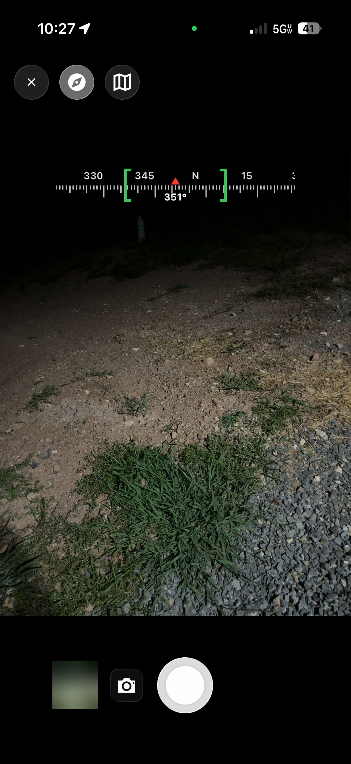
Switch on the compass tape and a strip appears above the viewfinder with cardinal directions, degree markings, and your exact bearing under the center marker.

**The bearing you see is the bearing that gets saved.** Every photo records the direction the camera was facing, which then travels with the photo into the map view and into report templates.

To turn it on, open the in-app camera and tap the **compass button** in the top row of controls, next to Close. Your choice sticks, so leave it on and it returns next time.

<figure><img src="https://3544178300-files.gitbook.io/~/files/v0/b/gitbook-x-prod.appspot.com/o/spaces%2FJ8P3pqhxdFwQkIOjOUut%2Fuploads%2Fgit-blob-4bea87e03c978d371cedeec6455ac66e4cf1349c%2Fcamera-compass-tape.jpg?alt=media" alt="The Codifi camera viewfinder with a compass tape across the top reading 351 degrees, with green brackets on either side of the marker"><figcaption><p>The tape sits above the viewfinder, never in the photo. The red marker is the direction the camera is facing — here <strong>351°</strong> — and the green brackets show how tight the compass reading currently is.</p></figcaption></figure>

{% hint style="info" %}
**The tape never appears in your photos.** It is a viewfinder overlay only. The bearing is stored invisibly with the photo's data.
{% endhint %}

***

## The Live Map

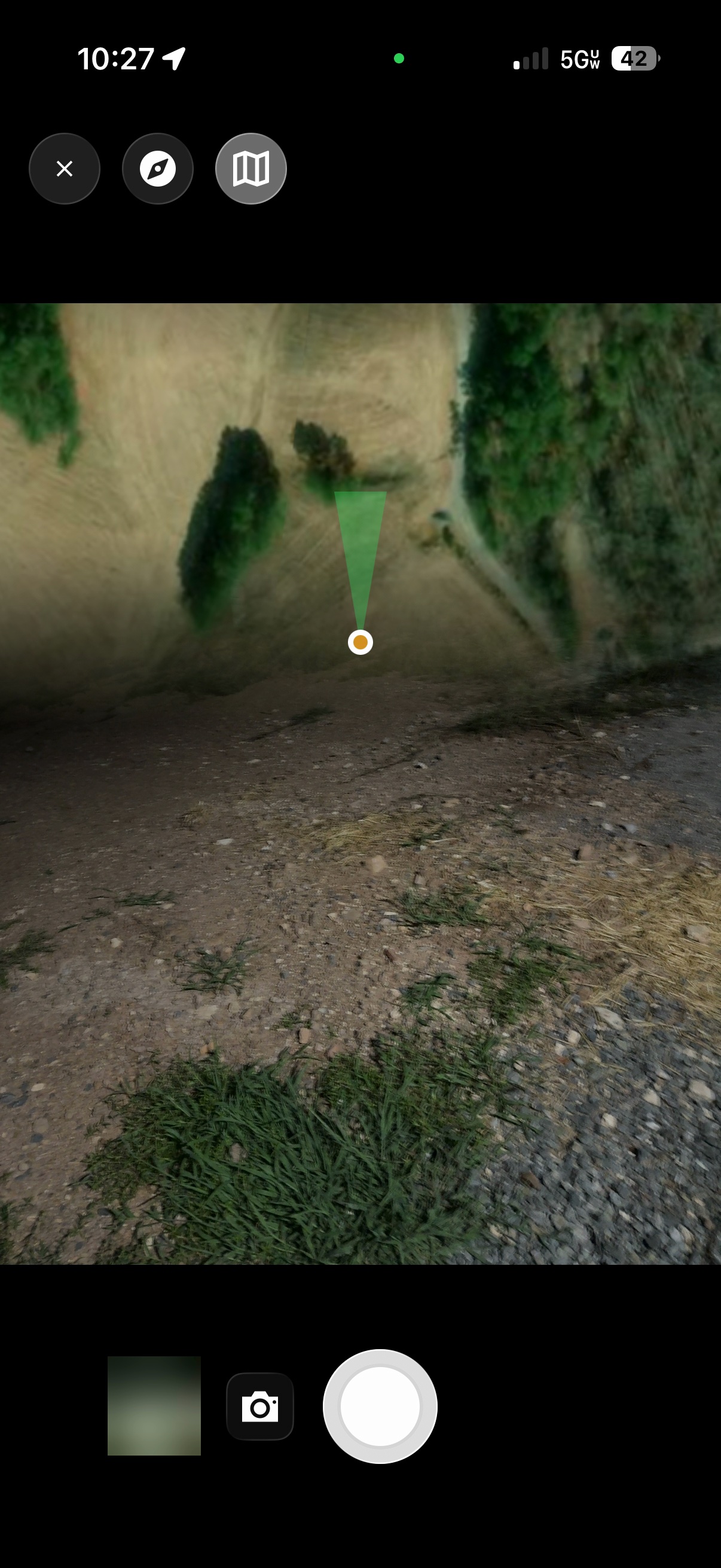
Tap the **map button**, right next to the compass button, and a satellite view spreads across the top of the viewfinder, rotated to your heading so that what is ahead of you on the ground is ahead of you on the map.

You sit at the bottom of the map with a cone showing the direction you are facing. If the imagery looks slightly off from what you can see, drag sideways on the map to twist it into alignment. A small chip tracks your adjustment, and tapping it snaps back to the compass.

The mini-map and the compass tape share the same slot, so switching one on swaps the other out.

<figure><img src="https://3544178300-files.gitbook.io/~/files/v0/b/gitbook-x-prod.appspot.com/o/spaces%2FJ8P3pqhxdFwQkIOjOUut%2Fuploads%2Fgit-blob-364af3d9021cb00234ce7c0bf3d10b4814ae9efa%2Fcamera-live-map.jpg?alt=media" alt="The camera viewfinder with a heading-up satellite mini-map across the top and a green cone spreading from an amber dot at the bottom of the map"><figcaption><p>The mini-map takes the same slot as the tape. You are the amber dot at the bottom, and the green cone points where the camera is aimed — narrowing as the compass reading gets more precise.</p></figcaption></figure>

***

## How Much to Trust the Reading

A phone compass is only as good as its surroundings. Metal, vehicles, and magnetic case closures all pull it around, and until now the app had no way of telling you that was happening.

Codifi now shows compass confidence in two places:

* **On the camera tape**, as brackets around your heading. Tight green brackets mean a precise reading. Wide brackets mean the compass is unsure.
* **In the Live Data bar** on the Project map, as a number next to your heading.

When the compass genuinely needs the figure-eight calibration, Codifi now lets iOS ask for it rather than carrying on with a bad reading.

{% hint style="warning" %}
**Wide brackets before an important capture?** Step away from the vehicle, take your device out of a magnetic case, and wave it in a figure eight. The brackets should tighten within a second or two.
{% endhint %}

***

## True North, Worked Out for You

Every heading in Codifi is referenced to **true north**. The app calculates the magnetic declination for your exact position and applies it, so the bearings you record line up with your maps and your Overlays without any mental arithmetic.

This applies everywhere a heading appears: the camera tape, the Live Data bar, offset capture, and the direction saved with each photo.

***

## Seeing the Bearing Afterwards

The direction a photo was taken shows up in three places once it syncs:

| Where                     | What you see                                                                                         |
| ------------------------- | ---------------------------------------------------------------------------------------------------- |
| **Photo details, mobile** | The bearing listed with the rest of the photo's metadata.                                            |
| **Project Media, web**    | The bearing in the details panel beside the image.                                                   |
| **Report templates**      | The bearing in degrees, or converted to a cardinal or octant label, printed straight into a caption. |

***

## Related

* [Live Data Bar & GPS Widgets](/codifi-docs/mobile-app/mapping-locations/gps-and-live-data/live-data-bar-and-widgets.md)
* [Capturing Photos & Media](/codifi-docs/mobile-app/capturing-photos-and-media.md)